3 MIN READ
Air Temperature Inversion Effects on Pesticide Spray Drift
February 23, 2022
Get Year-Round Updates From Our Agronomic Experts
Introduction
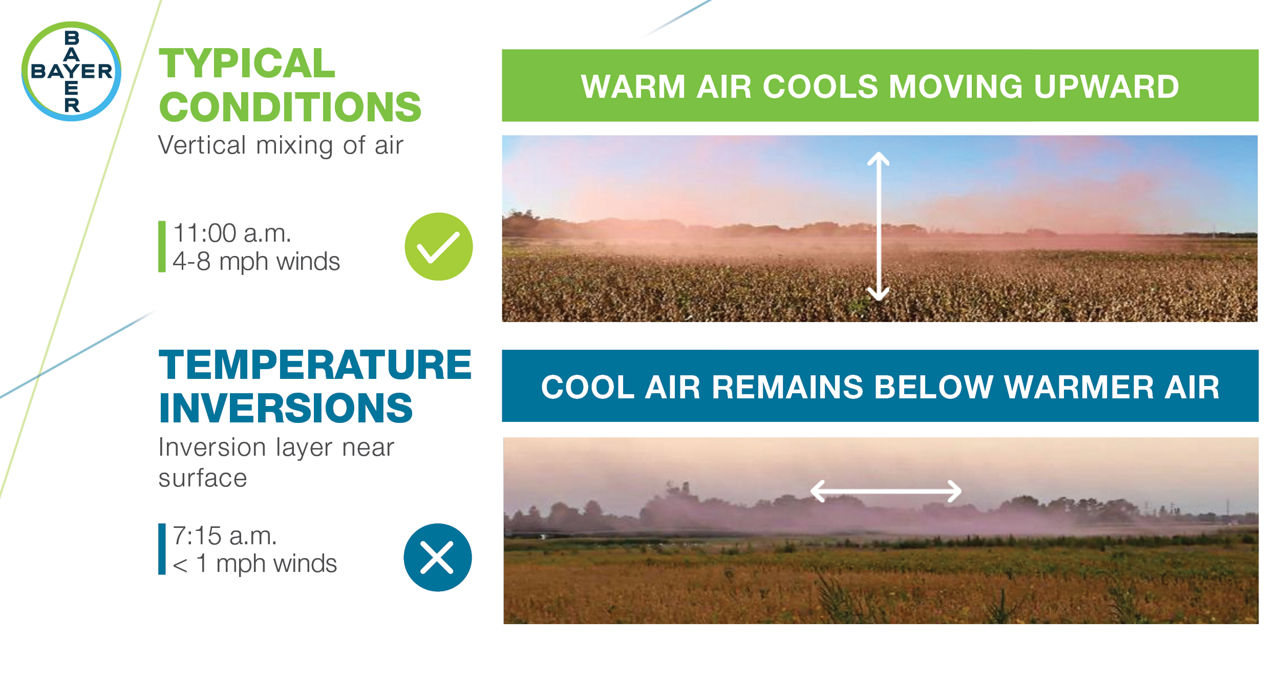
Pesticide spray drift can occur under air temperature inversion conditions. Air temperature inversions occur when cooler air forms closest to the surface below a layer of warmer air. While temperature inversions may develop at any time of the day, they are most likely to form during late afternoon or early evening and may persist through the morning hours. Temperature inversions create the conditions for small spray droplets to drift to nontarget areas. Some pesticide labels restrict applications made during inversions. Learning how to recognize when a temperature inversion occurs can help applicators avoid potential spray drift.
Inversion Effects on Spray Droplets
Air temperatures in crop fields are typically warmest near the ground and cooler at higher elevations. When an inversion occurs, the air near the crop or soil surface is cooler than the air above.1 The result is a very stable layer of air that prevents vertical air motion and can cause small droplets to be suspended for hours, potentially through the night and into the morning. Small spray droplets (200 microns or less) can become suspended in an inversion layer.1 These droplets can move to nontarget areas, potentially damaging susceptible crops or other vegetation with wind speeds as low as 1 mph.1 Applicators should not confuse spray drift during an inversion with herbicide movement through volatilization which is when a liquid spray droplet converts to gas. Small spray droplets from any application of an herbicide can move to nontarget areas during an air temperature inversion.
Spray Timing
Early in the morning when wind speeds are low (<3 mph) may seem like a good time to spray herbicides. However, temperature inversions are likely to occur when overnight skies are clear with calm winds making one of the worst times to spray in the early morning.1 An inversion usually persists for an hour or more after sunrise on a clear, calm day depending on the surface conditions. Ground fog or moisture on plant leaves are indicators that an inversion exists. In the morning when skies are clear, wait until the surface air begins to warm (generally 3 °F from the morning low) or winds increase (>3 mph) to ensure the inversion has lifted.
The beginnings of an air temperature inversion can occur in the late afternoon when air and soil temperatures begin to cool. Evening inversions may pose a greater risk for spray drift compared to morning inversions because once formed they can persist as long as skies remain clear. Once formed, the inversion will continue to intensify until shortly after sunrise. Windy or cloudy conditions will eventually disrupt the inversion. The worst-case drift scenario in an inversion is when low wind speeds also occur, moving small spray particles long distances.1
In mountainous areas, protected valleys, low areas, and shaded hillsides, cold air drainage can cause intense inversions. Applicators should be aware of the increased potential for inversion development and the increased risk of spray drift in these areas.1
Identifying an Inversion
Applicators can confirm the presence of an inversion by measuring the air temperature at two heights: 6 to 12 inches above the sprayed surface (soil if no crop is emerged or above the crop canopy) and 8 to 10 feet above the surface to be sprayed. An inversion exists when the temperature at the higher level is greater than the temperature at the lower level. The greater the temperature difference between the two levels, the more intense the inversion, and the more stable the lower atmosphere.1
Precise measuring of temperatures at the soil or crop surface as well as 8 to 10 feet above the surface can be impractical. The following conditions indicate that a surface temperature inversion is likely to be present.2
Mist, fog, dew, or frost is present.
Dust or smoke hangs in the air and moves sideways just above the surface. An applicator can generate smoke to test for the presence of an inversion. Smoke that layers and moves laterally in a concentrated cloud (under low wind conditions) indicates an inversion, while smoke that moves upward and rapidly dissipates indicates good vertical air mixing.
Cumulous clouds disperse as evening approaches.
Consistent wind speed is less than 6.8 miles per hour in the evening and overnight
Cool, off-slope breezes develop in the evening or overnight.
Distant sounds become easier to hear.
Distant smells are more distinct during the evening than during the day.
Contact your local Bayer representative for more information on herbicide application requirements.
Sources:
1Enz, J., Hofman, V., and Thostenson, A. 2019. Air temperature inversions: causes, characteristics and potential effects on pesticide spray drift. North Dakota State University Extension publication AE1705. www.ag.ndsu.edu.
2Townsend, L. 2017. Surface temperature inversions and spray drift. University of Kentucky Pest News. https://kentuckypestnews.wordpress.com.
Web sources verified 01/22. 5017_S2
Disclaimer
ALWAYS READ AND FOLLOW GRAIN MARKETING AND ALL OTHER STEWARDSHIP PRACTICES AND PESTICIDE LABEL DIRECTIONS.